


The Search so Far
The search status as of mid August 2023: most of the looking isn't in the water.

Where in the world is the America?

I will let you in on my secret. I have been looking for the America for a couple of years already.
In my post “Origin Stories” I made the point that I have been thinking about this for many years. In a future post I will expand more on my experience for this sort of thing. Right now, I hope to bring you up to date on the work we’ve done to find the America. Over the past two years, we’ve researched online and in libraries and at historical societies, visited relevant sites, interviewed people who have local knowledge and scanned the river bottom with acoustic and magnetic instruments. We’ve reached the stage where it’s time to begin to dive on the areas that look promising. I use “we” because I’ve had help from some friends and a professional on this task. Again, more on them in the future.
Also, let me add context by describing a bit of the history as well as the geography of the wreck site because these things are important to the story.
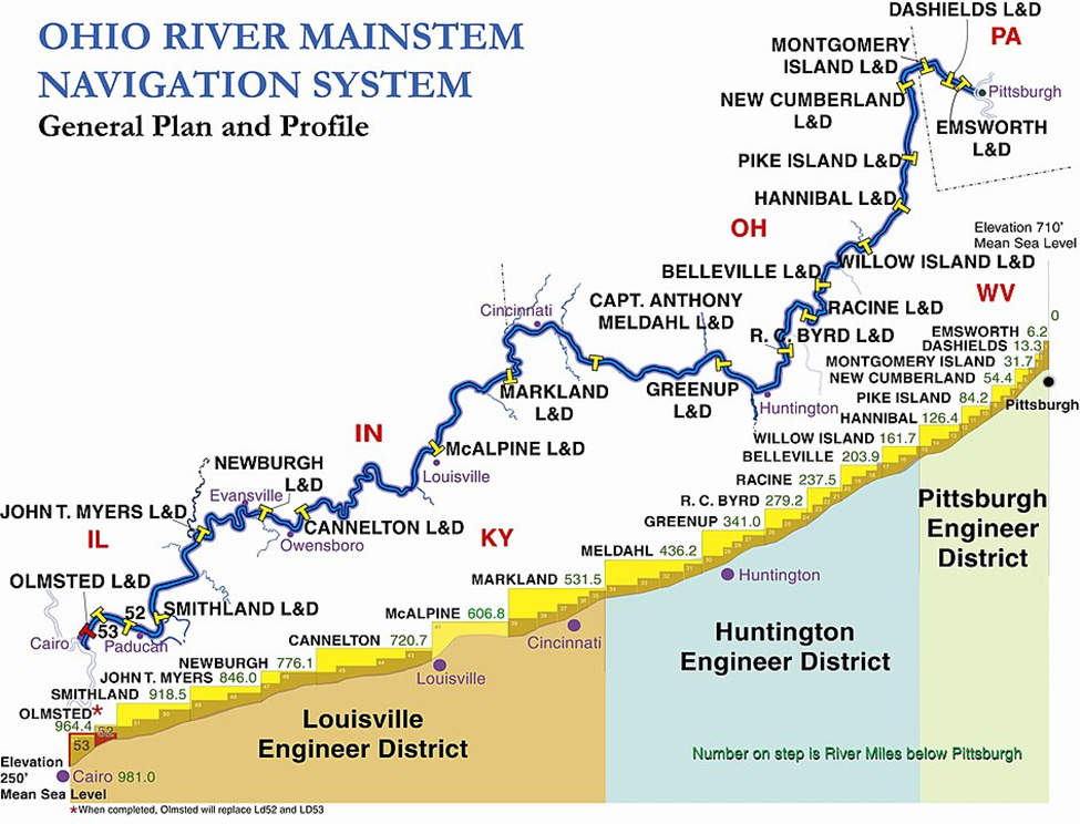
The Ohio River descends from Cincinnati to Louisville in a generally southwest manner over the course of 130 river miles. Today there is a US Army Corps of Engineers (USACE) locks and dam called Markland that regulates river levels for the purpose of sustaining commercial navigation and for flood control. Markland Dam raises the river level by about 35 feet. Starting in the 1920s and until 2018 there were a greater number of smaller locks and dams that generally raised river pool levels by five to six feet. At one point there were 53 locks and dams. At the time of the accident in 1868, there were no dams on the Ohio, so it was a free-flowing river with navigation hampered by floods, low water periods and other hazards such as snags and riverboat wreckage.
The section of river for this story is about five miles above today’s Markland Dam. The closest town is Warsaw, Kentucky. If you’ve visited Belterra Casino in Indiana, you have been in the neighborhood.

Both embedded images are rich with detail. If you look carefully, you can see the current locks and dams (yellow T’s) on the USACE map and the 53 original structures (light brown “steps”). On the satellite photo from Google Maps, you will see Indiana on the north (upper) part of the image and Kentucky to the south. The outskirts of Warsaw are seen lower left. A creek in Indiana called Byrant’s Creek is on the upper left. On the right is a large bend in the river at Sugar Creek in Kentucky. The actual length of the river shown in this image is about 4.5 miles between these two tributaries.
A key feature is the Indiana-Kentucky border shown as a dashed white line in the river channel. As you can see, Kentucky controls most of the river, but not entirely. Why? The river is broader today than it was when the state border was drawn. Why is that? The USACE locks and dams have raised the height of the river, making it wider at the same time. So, the 1868 Indiana bank is shown by this dashed white line.
Why is this important? The documents of the accident state that the collision occurred downstream of the big bend in the river with the United States headed down (east to west on the map) at about 20 mph and the America was headed upriver at about 10 mph. At this closing speed of 30 mph, the range between the steamboats narrowed at a rate of one mile every two minutes. The account states that the pilots sighted each other at a range of about one mile on that dark and rainy December night. The pilots had two minutes to work out a safe passage.
After the collision and fire, both boats pushed up on the Indiana bank at a place called “Rayl’s Landing” as passengers and crew evacuated while the boats continued to burn. The United States was secured to the shore, but America broke loose, drifted downriver and eventually sank near the mouth of Bryant’s Creek.
So, the area to search becomes clearer. The wreck of the America must be a bit south of the dashed line somewhere on the left portion of the satellite image.

Please note: I intend to describe the accident in greater detail, some of the notable people involved, and the aftermath in future posts. If any of my readers are impatient for more detail now, you can read the Wikipedia article that describes it here.
https://en.wikipedia.org/wiki/United_States_and_America_steamboat_disaster
Coming soon- Tools of the Search.